Turn Geospatial Data Into Searchable, Actionable Intelligence
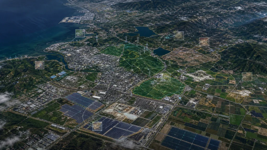
EDGE C helps geospatial, satellite, GIS, climate data, and location intelligence companies build AI systems that detect objects, monitor change, structure visual data, and make large geospatial datasets easier to search, analyze, and deliver.
We work with satellite imagery, drone imagery, aerial data, GIS layers, historical imagery, environmental datasets, inspection photos, and other visual/geospatial inputs to help data platforms create intelligence layers their users can actually use.
Build smarter geospatial products, faster workflows, and AI-powered intelligence tools on top of your visual and location data.
Geospatial and satellite data companies are no longer only delivering imagery, maps, or static datasets. Customers increasingly expect answers, alerts, dashboards, APIs, and decision-ready intelligence.
The market is shifting from raw data access toward applied analytics, AI-assisted interpretation, automated monitoring, and natural-language exploration.
According to Grand View Research, the global earth observation market was valued at USD 5.1 billion in 2024 and is projected to reach USD 7.24 billion by 2030, driven by increasing use of satellite imagery and remote sensing technologies. (Grand View Research)
According to Space Foundation, the global space economy reached a record USD 613 billion in 2024, with commercial activity representing the majority of sector growth. (Space Foundation)
According to NASA Earthdata, NASA’s Earthdata Search provides access to more than 2.2 billion Earth observation records, showing the scale of available satellite and environmental data that users now need to discover, filter, analyze, and apply. (Earthdata Search)
According to the Copernicus Data Space Ecosystem Annual Report 2024, the platform held nearly 80 petabytes of online data, published more than 34 million new Sentinel products, and delivered more than 200 petabytes of Earth observation data in 2024. (Cloudferro)
This growth creates a clear opportunity for geospatial, satellite, and data platform companies: move beyond data delivery and build intelligence products that help customers detect what matters, understand change, and take action faster.
Geospatial data platforms often sit on valuable datasets, but users still struggle to extract timely, practical insight from them.
Imagery, vector layers, climate datasets, sensor feeds, and historical archives can become difficult to search, compare, label, enrich, and operationalize at scale. Customers may have access to the data, but not the intelligence layer needed to use it efficiently.
Common challenges include:
Geospatial data volume is growing quickly, but customer expectations are growing even faster.
Users do not only want imagery. They want to know what changed, what assets exist, where risks are emerging, which areas need attention, and how to integrate insights into their own products and workflows.
According to Global Market Insights, the global geospatial analytics market was valued at USD 38.3 billion in 2024 and is projected to grow at a 13.6% CAGR from 2025 to 2034, driven by demand for location-based services, smart cities, and real-time data analytics. (Global Market Insights Inc.)
According to USGS, making Landsat data available at no cost significantly expanded access and enabled broader use for scientific research and land management decisions. This reflects a wider industry trend: more accessible geospatial data increases demand for tools that help users apply it effectively. (USGS)
According to NASA Earth Observations, users can browse and download imagery from more than 50 global datasets, with daily, weekly, and monthly snapshots available in multiple formats. (NASA Earth Observations (NEO))
The risk for geospatial and satellite data companies is not a lack of data. The risk is that valuable data remains underused because it is difficult to search, interpret, automate, or connect to real business decisions.
Companies that build intelligence layers on top of their data can deliver higher-value products, improve user retention, shorten analysis workflows, and differentiate in a crowded market.
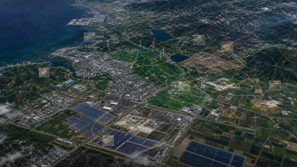
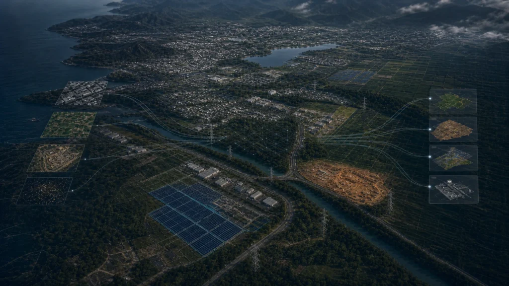
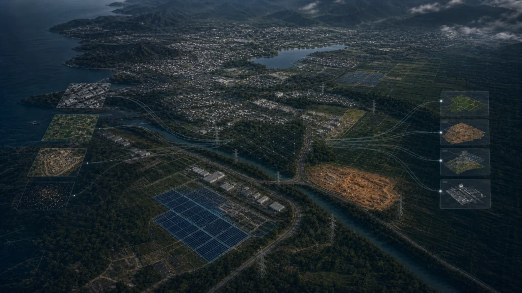
EDGE C helps geospatial, satellite, GIS, and data platform companies turn raw visual and location data into AI-powered intelligence products.
We build systems that detect objects, classify features, monitor change, enrich GIS layers, structure imagery, and create searchable datasets. These systems can be delivered through dashboards, APIs, alert workflows, reports, map interfaces, or natural-language query tools.
EDGE C can help you build:
EDGE C does not sell satellite data or claim ownership of proprietary datasets. We help you build intelligence layers using your own data, third-party data, open data, customer-provided data, or available visual and geospatial sources.
For Geospatial, Satellite & Data Platforms, relevant data sources may include:
Built Environment & Infrastructure
1. AI-Powered Object Detection for Geospatial Products
EDGE C can help detect buildings, roads, vehicles, infrastructure, energy assets, land features, or customer-specific objects from imagery.
Business value: Turn imagery into structured datasets that can power maps, analytics products, dashboards, and customer-facing tools.
2. Change Detection Across Time-Series Imagery
Compare historical and current imagery to identify new construction, land clearing, infrastructure expansion, environmental change, or site activity.
Business value: Help users understand what changed without manually comparing large volumes of imagery.
3. Searchable Satellite and Aerial Imagery
Create systems that allow users to search imagery by object type, location, time period, detected activity, risk category, or asset class.
Business value: Make large imagery archives easier to explore and monetize through higher-value user experiences.
4. GIS Layer Enrichment
Use AI detections to create or update GIS-ready layers with feature locations, classifications, confidence scores, timestamps, and metadata.
Business value: Improve data usability for customers who need structured outputs rather than raw imagery alone.
5. Natural-Language Geospatial Query Tools
Build AI-powered query systems that allow users to ask questions across imagery, GIS layers, metadata, and structured datasets.
Business value: Reduce friction for non-technical users and make complex geospatial datasets easier to use across teams.
6. Customer-Facing Monitoring Dashboards
Create dashboards that show detected changes, asset counts, risk zones, alerts, map layers, and trend summaries.
Business value: Turn geospatial data into recurring intelligence products that support decision-making and customer engagement.
7. Automated Reporting and Alert Workflows
Generate reports or alerts when specific objects, changes, or risk conditions are detected in selected areas.
Business value: Help customers move from periodic manual analysis to continuous monitoring and faster response.
EDGE C can help geospatial and satellite data platforms support natural-language questions such as:
Instead of forcing users to manually inspect imagery or navigate complex datasets, queryable intelligence helps them move directly from question to answer.
Geospatial, Satellite & Data Platforms → AI Detection / Analysis → Structured Intelligence → Dashboards / APIs / Alerts / Reports / Query System
1. Data Ingestion
EDGE C helps ingest satellite imagery, drone imagery, aerial imagery, GIS layers, historical imagery, customer-uploaded files, metadata, environmental data, and other visual/geospatial inputs.
2. AI Detection & Classification
Computer vision models detect and classify relevant objects, assets, land features, changes, or risk signals based on the platform’s data and customer use cases.
3. Structured Dataset Creation
Detected features are converted into structured datasets with coordinates, labels, timestamps, confidence scores, source references, and metadata.
4. Monitoring & Change Detection
The system compares current and historical data to identify new activity, missing features, expansion, land-use change, environmental shifts, or other meaningful events.
5. Delivery Layer
Outputs are delivered through dashboards, GIS-ready layers, APIs, alerts, automated reports, map interfaces, or natural-language query tools.
EDGE C can help geospatial, satellite, and data platform companies build:
Geospatial, satellite, and data platform companies already have access to valuable imagery, layers, and location datasets. The next opportunity is turning that data into structured intelligence that users can search, monitor, query, and act on.
EDGE C helps you build AI systems that convert visual and geospatial data into practical products: detections, dashboards, GIS layers, APIs, alerts, reports, and natural-language query tools.
Tell us about your project. We’ll be in touch soon.
To get register with Edgec please send a request on below email, Thank you!
info@edgec.io