
EDGE C helps climate, environmental, and agriculture technology companies build AI systems that detect land features, monitor change, analyze field conditions, map assets, and turn visual/geospatial data into structured intelligence.
We work with satellite imagery, drone imagery, aerial data, GIS layers, environmental datasets, climate data, inspection photos, historical imagery, sensor data, and operational records to help teams monitor land, crops, water, vegetation, infrastructure, and environmental risk at scale.
From crop monitoring and land-use change to climate risk, water stress, environmental compliance, and agricultural intelligence, EDGE C builds visual intelligence systems that help teams understand what is happening, what changed, and where action is needed.
Build smarter climate, environmental, and agricultural intelligence systems using visual and geospatial data.
Climate, environmental, and agriculture organizations are under growing pressure to make faster, more accurate decisions about land, water, crops, risk, and resource use.
Farmers, AgTech platforms, insurers, food companies, climate risk teams, environmental agencies, and sustainability organizations increasingly depend on satellite imagery, drone imagery, field photos, GIS layers, weather data, soil data, crop records, and environmental datasets.
But having more data does not automatically create better decisions.
The real opportunity is to turn visual and geospatial data into structured intelligence that can detect conditions, monitor change, identify risk, and support action at scale.
According to NASA Earthdata, NASA satellite data supports agriculture and water management decisions using datasets such as land surface reflectance, land temperature, vegetation greenness, and crop extent. This shows how Earth observation data is becoming essential for agricultural and environmental decision-making. (NASA Earthdata)
According to NASA Harvest, satellite Earth observations are being used by public and private organizations to support food security, agriculture, and environmental resilience in the U.S. and globally. (Harvest Portal)
According to the World Bank’s Global Water Monitoring Report, the world is losing 324 billion cubic meters of freshwater every year, enough to meet the annual needs of 280 million people, with worsening droughts and poor land and water management contributing to the problem. (World Bank)
According to the World Food Programme’s Global Report on Food Crises 2025, more than 295 million people across 53 countries and territories experienced acute hunger in 2024, with conflict, economic shocks, climate extremes, and displacement among the key drivers. (World Food Programme)
For climate, environmental, and AgTech companies, the shift is clear: organizations need systems that can convert large volumes of imagery, land data, environmental signals, and field records into timely intelligence.
Climate, environmental, and agriculture operations are difficult to monitor because conditions change across time, geography, seasons, weather events, and human activity.
Crops grow and decline. Vegetation changes. Water availability shifts. Land is cleared or restored. Flooding, drought, erosion, pest pressure, and environmental damage can emerge quickly. Field teams, analysts, and decision-makers often need to understand these changes across large areas.
Many teams still rely on manual field checks, delayed reports, disconnected GIS tools, static maps, spreadsheets, separate image folders, and inconsistent monitoring workflows.
That creates visibility gaps.
Common challenges include:
Climate, environmental, and agriculture teams are facing a combination of rising risk, growing data volume, and increasing demand for measurable action.
Organizations need to monitor land and resource conditions more frequently. AgTech platforms need better intelligence products. Environmental teams need stronger evidence for reporting and compliance. Food and agriculture stakeholders need better visibility into yield risk, water stress, and land degradation.
According to the FAO’s State of Food and Agriculture 2025, the report focuses on human-induced land degradation and its effects on agricultural production, including how cropland degradation contributes to yield gaps worldwide. (Open Knowledge FAO)
According to the FAO, the 2025 edition of The State of the World’s Land and Water Resources for Food and Agriculture underscores the urgent challenges of human-induced land degradation, water scarcity, and climate change, and their impact on agricultural productivity and ecosystems. (FAOHome)
According to the UN Handbook on Remote Sensing for Agricultural Statistics, remote sensing can help generate high-quality land-use maps and crop yield predictions, supporting national estimates and sustainable development. (FAO EOStat)
Organizations that continue relying only on manual review and disconnected workflows risk:
The organizations that move faster will be those that turn visual, geospatial, climate, and environmental data into structured intelligence.
EDGE C builds AI-powered visual intelligence systems for climate, environmental, and agriculture technology organizations.
We help companies convert raw visual and geospatial data into structured, searchable, and actionable intelligence. Instead of manually reviewing imagery, field photos, maps, and environmental datasets, your teams can use AI systems to detect features, classify conditions, monitor change, generate alerts, create reports, and query environmental or agricultural data.
EDGE C can help build systems that:
EDGE C does not sell satellite data or claim ownership of proprietary agricultural or environmental datasets. We help you build intelligence layers using your own data, third-party data, open data, customer-provided data, or available visual and geospatial sources.
For Climate, Environmental & Agriculture (AgTech), relevant data sources may include:
1. Crop and Field Monitoring
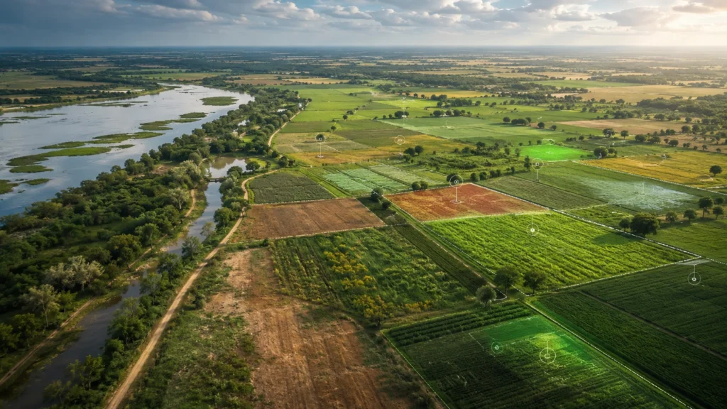
EDGE C can help analyze satellite imagery, drone imagery, field photos, and GIS layers to monitor crop fields, field boundaries, vegetation patterns, and visible crop condition signals.
Business value: Improve field visibility, support faster agronomic decisions, and help AgTech platforms deliver more useful intelligence to farmers and enterprise customers.
2. Land-Use Change Detection
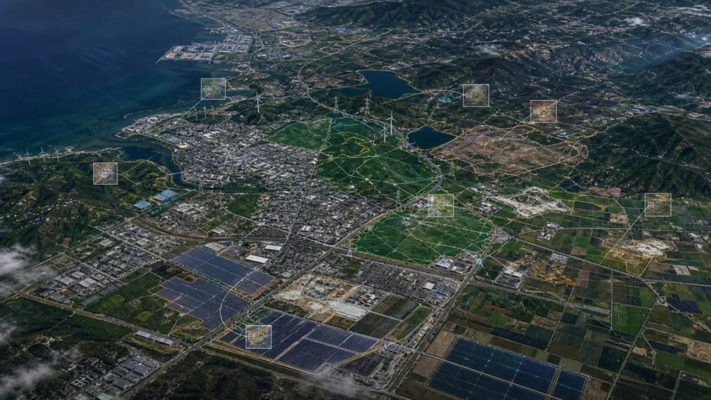
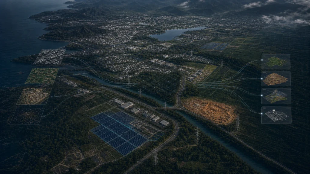
Compare historical and current imagery to detect land clearing, agricultural expansion, urban growth, road development, forest loss, restoration activity, or new site disturbance.
Business value: Help environmental, climate, and land intelligence teams identify change faster and maintain more current geospatial datasets.
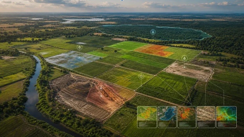
3. Water and Drought Risk Monitoring
Use visual and geospatial data to monitor water bodies, irrigation coverage, water pooling, drought-affected areas, wetland changes, and shifts in surface water visibility.
Business value: Support water management, climate risk analysis, farm planning, insurance workflows, and environmental reporting.
4. Environmental Compliance and Monitoring
Detect visible environmental changes such as land disturbance, vegetation loss, erosion, waste accumulation, mining expansion, or changes near protected areas.
Business value: Improve monitoring consistency and help teams create stronger evidence for compliance, sustainability, and environmental reporting.
5. Climate Risk Intelligence Dashboards
Build dashboards that combine satellite imagery, environmental layers, weather data, risk zones, detected changes, alerts, and field-level insights.
Business value: Help climate platforms and environmental teams turn complex datasets into clearer decision-support tools.
6. GIS-Ready Agricultural and Environmental Datasets
Convert detections and classifications into structured geospatial layers with coordinates, categories, timestamps, confidence scores, and metadata.
Business value: Create cleaner datasets for analysis, reporting, APIs, customer products, and internal decision-making.
7. Natural-Language Environmental Query Tools
Create query systems that allow users to ask questions across imagery, GIS layers, field records, climate datasets, and detected environmental changes.
Business value: Make complex geospatial and environmental intelligence easier for non-technical users to access and apply.
EDGE C can help climate, environmental, and AgTech teams ask natural-language questions across their visual, geospatial, and environmental data.
Example queries include:
Instead of manually searching through imagery, maps, field reports, and environmental datasets, teams can query a structured intelligence layer built from their visual and geospatial data.
1. Data Ingestion
EDGE C helps ingest satellite imagery, drone imagery, aerial imagery, GIS layers, climate datasets, environmental records, field photos, historical imagery, farm records, and sensor or operational data.
2. AI Detection & Classification
Computer vision models detect and classify relevant crops, field boundaries, vegetation patterns, water bodies, land-use changes, environmental features, risks, and visible condition signals.
3. Structured Dataset Creation
Detected findings are converted into structured datasets with coordinates, field IDs, categories, timestamps, confidence scores, source references, and metadata.
4. Monitoring & Change Detection
The system compares current and historical data to identify vegetation change, land clearing, water change, flooding, drought impact, erosion, crop condition shifts, or environmental disturbance.
5. Delivery Layer
Insights are delivered through dashboards, GIS-ready layers, APIs, alerts, automated reports, map interfaces, or natural-language query systems.
EDGE C can help climate, environmental, and agriculture technology organizations build:
Climate, environmental, and AgTech organizations already have access to valuable visual, geospatial, and environmental data. The next step is turning that data into structured intelligence that helps teams monitor change, detect risk, reduce manual analysis, and make faster decisions.
EDGE C helps you build AI systems that connect imagery, GIS layers, climate data, field records, and environmental datasets into practical tools your teams and customers can use.
Turn Environmental Data Into Actionable Intelligence
Tell us about your project. We’ll be in touch soon.
To get register with Edgec please send a request on below email, Thank you!
info@edgec.io